


Candy Voting District, Benton County, Washington
About
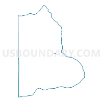
Outline

Summary
| Unique Area Identifier | 683452 |
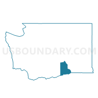
| Name | Candy Voting District |
| County | Benton County |
| State | Washington |
| Area (square miles) | 0.05 |
| Land Area (square miles) | 0.05 |
| Water Area (square miles) | 0.00 |
| % of Land Area | 100.00 |
| % of Water Area | 0.00 |
| Latitude of the Internal Point | 46.26416980 |
| Longtitude of the Internal Point | -119.36300450 |
Maps

Graphs
Select a template below for downloading or customizing gragh for Candy Voting District, Benton County, Washington


Neighbors
Neighoring Voting District (by Name) Neighboring Voting District on the Map
- Griffin Voting District, Benton County, WA
- West Richland 10 Voting District, Benton County, WA
- West Richland 9 Voting District, Benton County, WA